1 MPA information

Wdpaid:
555637379
Pa_def:
1
Name:
Irish Sea Front
Orig_name:
Irish Sea Front
Desig:
Marine Protected Area (OSPAR)
Desig_eng:
Marine Protected Area (OSPAR)
Desig_type:
Regional
Iucn_cat:
Not Reported
Int_crit:
Not Applicable
Marine:
2
Rep_m_area:
179
Gis_m_area:
179.570921529136
Rep_area:
179
Gis_area:
179.570721803641
Not_take:
Not Reported
Not_tk_take:
0
Status:
Designated
Status_yr:
2018
Gov_type:
Collaborative governance
Own_type:
Not Reported
Mang_auth:
OSPAR Commission
Mang_plan:
Verif:
State Verified
Metadata_i:
883
Sub_loc:
Not Reported
Parent_iso:
GBR
Iso3:
GBR

2 Data information

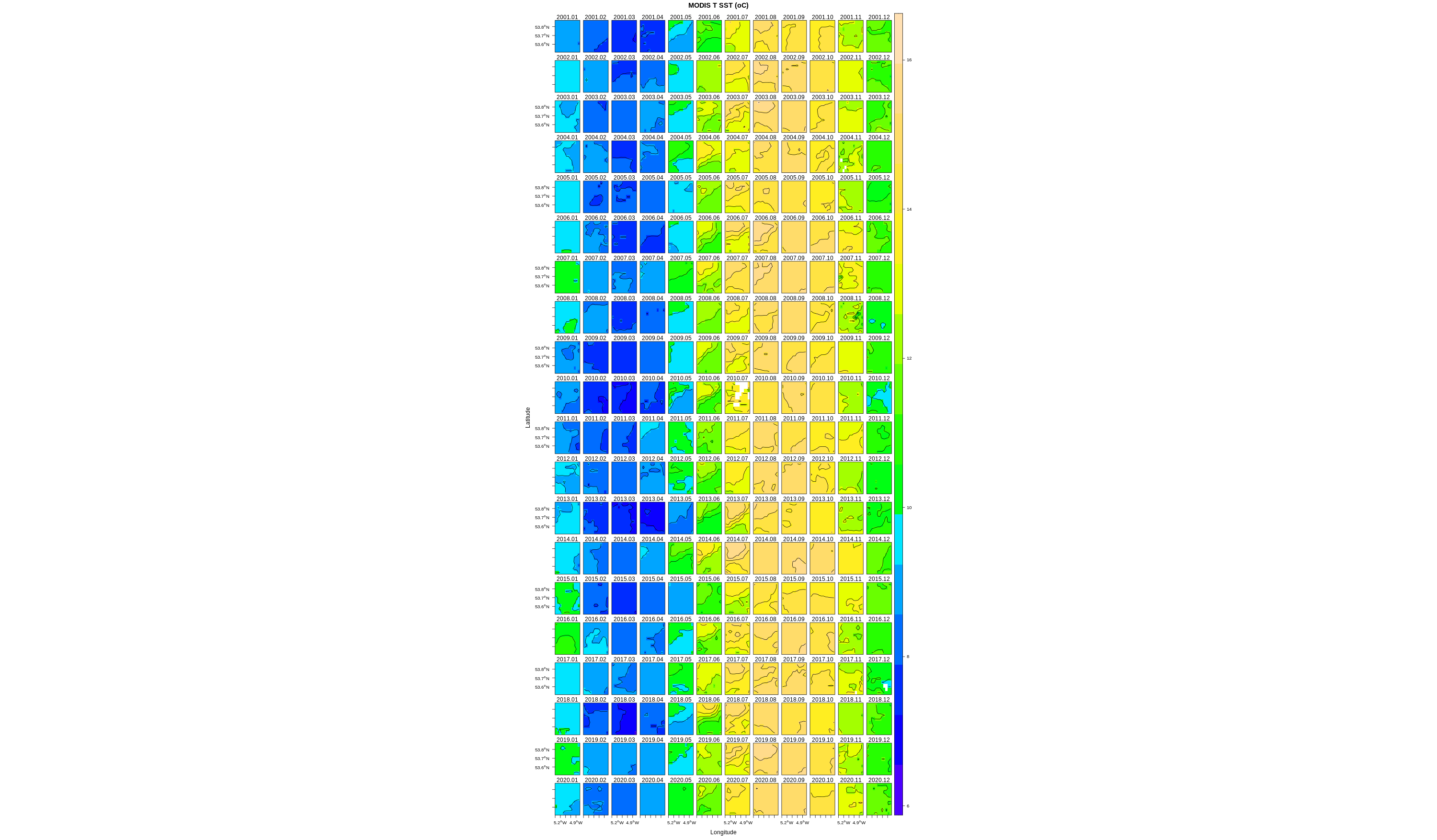
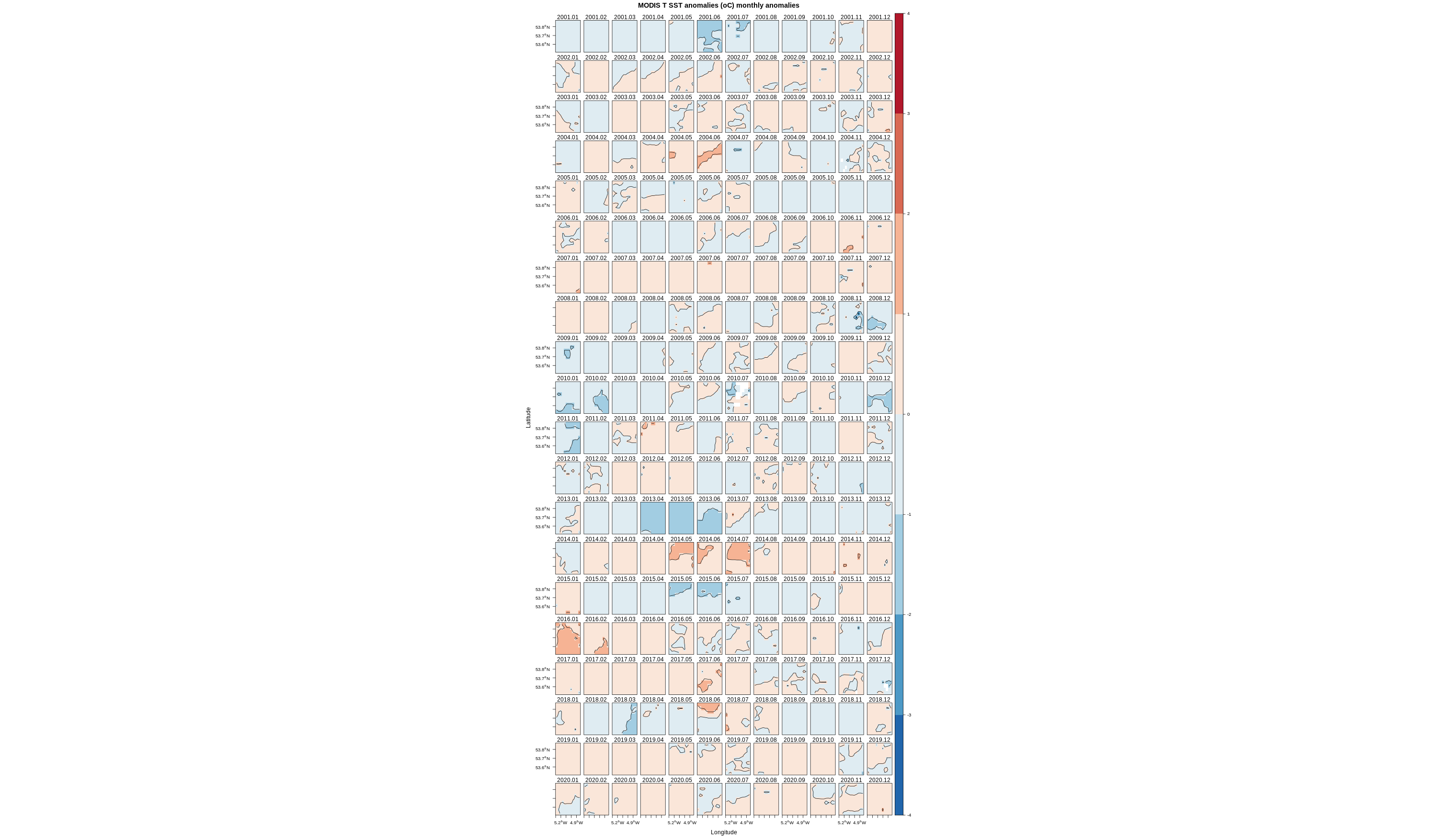
Monthly mean sea surface temperature (in degree-C at 4km resolution) derived from the MODIS-TERRA sensor (Satellite remote sensing Ocean color data): Sea surface temperature is the temperature of the water close to the sea surface. SST is a standard product from satellite-based thermal infra-red sensors, and optical sensors complemented with infrared bands.

Access metadata from landing page

3 Geographical extent

3.1 Coordinates

## [1] "West-Longitude: -5.2"
## [1] "South-Latitude: 53.61"
## [1] "East-Longitude: -4.92"
## [1] "North-Latitude: 53.77"

3.2 Defined area

Map tiles by Stamen Design, under CC BY 3.0. Data by OpenStreetMap, under ODbL.

4 Analysis (graphs)

4.1 Monthly composite

Click on the image to enlarge

4.2 Average

4.3 Monthly climatology

4.4 Monthly boxplot

5 Analysis (data)

5.1 Average seasonal decomposition

5.2 Download

name unite timerange pixelnb fracnbna fractsna mean sd min max varseason vartrend trendtest sen.slope
MODIS T SST oC 2001.01/2020.12 12 0.17 0 11.39655 2.532341 6.94 15.805 97.01784 0.0652164 0 0.0111676

Download analysis data (csv) [Time,“Time series”,“Seasonal component”,“Trend”,“Residual”]

6 Dynamic graphs

6.1 Time series


6.2 Seasonal component


6.3 Trend


6.4 Residual


7 References


The parameters are monthly data.

var gives the short name of the parameter processed.

timerange is the time range of the parameter.

pixelnb gives the number of x by x km pixels covering the defined geographical extent.

fracnbna is the percentage of missing data in the defined area over the time range.

fractsna is the percentage of missing value for the time series of the parameters. This time serie is calculated using the monthly mean of the pixel values inside the defined area.

mean is the average value of the parameter inside the defined area over the time range.

sd is the standard deviation of the parameter values inside the defined area over the time range.

min is the minimum of the parameter values inside the defined area over the time range.

max is the maximum of the parameter values inside the defined area over the time range.

The monthly time series X(t) of the parameter is decomposed as X(t)=S(t)+T(t)+I(t) (see Vantrepotte and Melin, 2009), where S, T, and I represent, respectively, a seasonal signal, a trend, and an irregular (or residual) component (or remainder). These components are presented in the figure “seasonal composition”.

In this framework:
varseason is the percentage of variance associated with the seasonal component and “vartrend” the percentage of variance associated with the linear component (the trend).

A statistical test (Kendall rank correlation coefficient) is performed on the linear component in order to assess the significance of a monotic trend:
trendtest gives the p.value associated to this test.

senslope gives the value of the Sen slope (alternately, Theil slope). This value is the median slope joining all pairs of observations and is expressed by quantity per year.

References: Vantrepotte, V. Melin, F. Temporal variability of 10-year global SeaWiFS time-series of phytoplankton chlorophyll a concentration ICES J. Mar. Sci., 2009, 66, 1547-1556

8 Open-notebook

Access MyBinder.org/Marine-Analyst virtual environment.
More info at Marine-Analyst.eu

This document produced by Marine-analyst.eu is licensed under CC BY-NC 4.0